Thursday, December 18, 2008

Caches of the Temple of the Cross


You may remember the above map as a smaller portion of a map that I posted in an earlier entry (it was annotated by Linda Schele) when I was discussing archaeologists that have excavated at Palenque. The map does not display those made by Miguel Angel Fernandez in the early 1940s where he found several caches in the Temple of the Cross and Sun.

Temple of the Cross

Temple of the Sun

The underground caching of objects by the ancient Maya people was a frequent ritual behavior and is evidenced in the archaeological record throughout the Maya Area, particularly within sacred temples. These caches often take the form of buried and covered pots that contain a variety of objects including things such as human bones, charred flowers, figurines and obsidian lances.

Photo Credit: Archaeologia Mexicana and Marco Antonio Pacheco/Raices

The pot on the left above was found in the Temple of the Cross by the Fernandez in 1941. When there are multiple caches in one building, the configuration of how they are laid out can have ritual or symbolic meaning. For instance, many are found in the shape of a cross or in the shape of a quincunx (one in each corner of the building and then one in the middle).


But the grouped cache excavated by Fernandez shown in the diagram above was of a very strange configuration that he postulated was in the shape of the big and little dipper (he also thought that it could be a coincidence). The layout does not quite fit these two constellations and the ancient Maya would surely have made it more precise, if that was their intention. What do you think it might represent or is this just a random "building ensoulment".

Here is a picture of some of the holes in the floor of the building. It was hard to take this photo, since I had to try to fit my camera through the screening device protecting the sanctuary. You may ask “how did Fernandez know where to dig for these caches?” He knew where they were because he could see the holes in the stucco of the floor where they had been patched up.

Saturday, November 22, 2008

Out of Context

There was a time in world history when people did not know that the act of taking artifacts from an ancient city would create serious obstacles for scholars who try to reconstruct that city's history and so people thoughtlessly grabbed them up and took them home with them. However in today's world when people are supposed to know better, the behavior still goes on. Many ancient objects from Mesoamerican are scattered in private collections and museums throughout the world, thus these objects are out of context and we don't know much about them. I tell you this as an introduction to the above article that I found on Google Books – an article that comes from a magazine called "Historical Magazine", published in 1859.

Above is a photo of an object found in Justin Kerr's online database (at http://www.famsi.org/research/kerr/) that is very similar to the one described in the above article as a "large sacrificial collar in polished granite, in the form of a horse-shoe, with deities carved around it. This collar...was used for putting over the necks of the victim, when laid down on the sacrificial stone for the purposes of decapitation." Archaeologists now call these collars "yokes" and we have NO proof that they were used for sacrificial purposes.


Here is another from Justin's photo collection. If the yoke in the article above was indeed found at Palenque, it is likely that it was an heirloom of an ancient Palenqeno because it is from a different culture along the coast of Veracruz. Scholars who study the culture of Veracruz have speculated about the use of these yokes, but as of this writing, the jury is still out as to how they were used in ancient times. It is suspected that they may have had something to do with the Mesoamerican ballgame, since we see figurines with similar yokes around their waists.

Tuesday, November 18, 2008

Soaking Up Knowledge

I would like to introduce you to a group of people who are making substantial contributions to my education. They have patiently mentored me and have enlightened me regarding subjects that were so new to me only 5 years ago. I have taken classes from all of them (except Dr. Miller) and they each teach subjects related to either the ancient cultures of Mexico and Guatemala or they are experts in Geographic Information Systems and geography. They will be helping guide me through my research and the dissertation.


Dr. David Stuart
Webpage @: http://www.finearts.utexas.edu/aah/art_history/faculty/stuart.cfm
Thanks to Jody Horton for use of the photo. Find her webpage at http://www.jodyhorton.com/site.html

Dr. Brian Stross

Webpage at http://uts.cc.utexas.edu/~strossb/


Dr. Jennifer Miller
Webpage at https://webspace.utexas.edu/jam5889/www/index.html


Dr. William Doolittle
Webpage at http://www.utexas.edu/courses/wd/


Dr. Karl Butzer
Webpage at https://webspace.utexas.edu/butzerkw/www/


Dr. Fred Valdez
Webpage: http://uts.cc.utexas.edu/~marl/

Saturday, November 1, 2008

The Tombs of Temple XVIII

Another archaeologist's name on Linda's map is "Sáenz" (first name César). He was one of several people who worked under Ruz. The building whose plan view that you see above was excavated and consolidated by Sáenz (Temple XVIII). He found 3 tombs in this building and they were rich with jade and carved shell.

A jade pendant was found in one of the tombs.


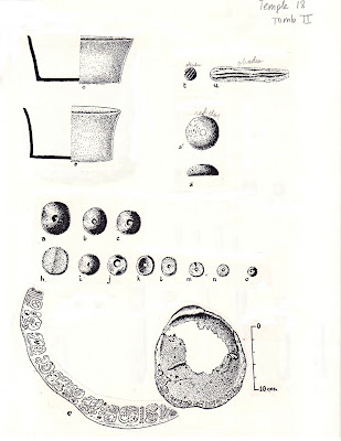
This is a drawing showing some of its ritual deposits found in Tomb II. There were things such as bowls, jade beads and a bone carving with maya glyphs upon it.

Tuesday, October 28, 2008

Zavala and Group IV


Zavala created a map of Group IV (displayed above) showing where the Tablet of the Slaves was found ("L" on the upper left-hand side of the map) as well as where a grave was uncovered that he called "tumba aislada". This tomb was uncovered while his crew was constructing the modern road leading into the site.

Saturday, October 25, 2008

Transitions

Today I begin the process of transitioning my blog away from one that addresses the conservation of Palenque, Mexico as an archaeological park, to a blog about Palenque GIS and the site's archaeological record. The map displayed above was annotated by Linda Schele upon a blueline print of a base map of the central precinct of Palenque.
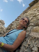
Here is a picture of Linda next to the Palace Tablet found in House E.

My guess is that she added the map notes in the late 70's and early 80's when she was helping Merle Green Robertson create a new map for the site. Although the Mexican authorities keep records that detail the operation and excavation # of each archaeological dig, this is the only map I have ever found that documents some of them. Those shown here are excavations that took place from 1951 to 1956 in the central precinct. I have digitally mapped this information, but this task is only a small piece of the data puzzle that I am putting together. In case you are curious about the names of the archaeologists on this map, I am going to tell you a little bit about each one of them over the next few entries.

Tablet of the Slaves

The name "Zavala" is shown on the map as having excavated in the Palace area. He worked at Palenque under the well-known Mexican archaeologist, Alberto Ruz. His full name was Lauro Jose Zavala. Linda's map above doesn't display Group IV, where Zavala also excavated and found a well preserved carved monument called "Temple of the Slaves" (above drawing by Linda). His crew was building the modern road into Palenque and accidentally came across a set of residential buildings that we now call Group IV.

Tuesday, September 2, 2008

Fuzzy Boundaries

Soon after you arrive at the main entrance gate to Palenque - the one where they take your 20 pesos and ask you what country you are from - you realize that there are other landowners that encroach into the park boundaries. All the painted signs along the road going up into the site are a dead give-away. The boundary for the park was established several years ago, but there are still people who own land within it. I have been told that the government would like to purchase these properties to better protect the site and its archaeology, but they haven't come up with the funds to do this yet.
The first sign you see right at that front gate is the all popular lodging, eating, drinking and music establishment of El Panchan, along with various other businesses. Panchan has some of the best food I have ever eaten and they employ outstanding chefs.

The next establishment along the road doesn't seem to have a name, but has a sign advertising bungalows.


Then there is a youth hostel...

A place called La Palapa...


Next comes Michol Palapa - The word "Michol" is also the name of the nearby river.

Kichanes cabanas and camping

Last, but not least is the Mayabelle. Ed Barnhart and his crew actually mapped part of this property, since the land contains ancient structures.

Tuesday, August 26, 2008

After 5 Thousand Years

I recently received a new National Geographic magazine collector's item publication in the mail.
As I was flipping through the softbound book, I noticed the messages contained on the inside of the front cover.
And then I noticed the inside of the back cover. Delfino Lopez Hidalgo, one of the administrators at the Palenque site from the INAH (the Instituto Nacional de Antropología e Historia) told me that the governor of Chiapas, as well a the National Secretary of Tourism had spent large amounts of money in tourism advertising in order to promote the state of Chiapas. Visit http://www.sectorturismo.gob.mx/wb/sectur/sect_buscador?q=chiapas
to see some of their information. Since visitation is up this year it seems to be working.

Saturday, August 23, 2008

Excusado del Palacio

You may recall a discussion in a previous posting about the possible existence of bathrooms in the Palace. This evening, while looking through many of our old books and enformes about Palenque, I came across the above diagram that was drawn under the direction of Mexican archaeologist, Miguel Angel Fernandez. He excavated at Palenque in the 1940's. The diagram illustrates part of the Palace tower court and clearly shows "la posición" that a man would be able take in order to relieve himself in "el hombre's estación". It even shows the physics of how it might operate. I guess we will have to continue to use our imagination regarding how the women's excusado works. I now have a new-found confidence in our Palenque tour guides because the information that they are giving their audiances comes from a pretty good source!

Wednesday, August 20, 2008

We shall come rejoicing, bringing in the sheaves.

I have been pondering what might be some of the causes for the increasing use of these large tour buses that are bringing more people into the site. I think that there are at least two reasons -- one of which is the ease of being able to book these tours over the Internet.

The other reason is due the efforts of this man. Back in the 1990's Mexican President Carlos Salinas de Gortari wanted to improve the road system, so he turned to private investors to construct and maintain sections of the highway system. In a nutshell, according to reports, he dramatically improved Mexico's tourism infrastructure. I am not implying that there is a toll road that leads to Palenque, but these buses come from all parts of Mexico, so the toll roads link the buses to the smaller roads in the transportation network that lead to Palenque.

There is a lot of information about Mexican toll roads and their toll charges at the "Mexexperience" website found here: http://www.mexperience.com/guide/essentials/toll_road_charges.htm

Another great resource for information about Mexican roads and their future is the Presidente Felipe Calderón Hinojosa's road infrastructure page. Above is a map that he posted of the existing road network.

And here is a map of the road network that the president would like to see by 2012. Interesting that he uses this date, which is coincidently the end of the Maya bak'tun cycle in the ancient calendar. Citings of this date are becoming a familiar refrain by so many people all over the world.

Saturday, August 16, 2008

Autobuses de Turismo

One of the most amazing things that I observed at the site are the number and variety of large tour buses, the majority of which are road worthy, air conditioned and comfortable. They usually seat about 40 to 50 people.
Here is another one that is trying to turn around in the tight parking area that is also used by the vendors, the guides, the tourists as well as other buses.
I love the ones that have the bright colors and that look like they have bug antlers. Those appendages are actually their rear view mirrors. These two buses are trying to squeeze by on the narrow two lane road that leads into the park.
Here I am sitting by the roadway counting each kind of vehicle that comes into the park (bus, car, taxi, etc.). I was a transportation planner in a previous life, so I felt very comfortable taking one hour traffic counts by mode. I did this on various days at various times throughout one week and estimated that there are an average of 4 large tour buses that come into the park every hour - during the SUMMER SEASON. If you multiply that out, it comes to an average of 50 buses each day during vacation season. Un-averaged counts would reflect that, there are more of these buses on Sundays, since Mexican nationals do not pay a park fee on Sundays and there are less buses on some of the weekdays.
There has been a increasing trend in the use of these large coaches over the years that local people have noticed. Their use impacts the local economy, sometimes in a negative way. The tour operator, knowing that he/she has promised the group that they would visit several cities and several sites in X number of days, funnels the people into a local hotel for one day and then the next, takes them up to Lakamha' (Palenque) for a few hours, puts them back into the bus and then they are on their way to the next location, without even seeing or spending their money in the little pueblo of Palenque.I placed the "tourist circuit" on a map to help you see how the people are taken by bus to the park entrance at the top of the hill and then they are lead (or self lead) through the circuit which is a distance of 1.2 miles or 1.9 kilometers downhill. They are given a set amount of time to make it through the site - to be back at the bus that is waiting either at the museum parking lot or the informal lot where it is being washed. Then they put them back into the bus and they are off again to the next destination.
And yes, some make it through the site faster than others and are happy to be able to relax after such a stimulating and very sweaty walk.

Friday, August 15, 2008

Tiendas de Portátiles

I created this map to show locations where the vendors are usually found at the site. I estimate that they use approximately 9,153 sq. meters of space in total.


With the exception of those vendors who are lucky enough to have a real booth with a roof, each person must have enough ground area to spread their goods out for display.


How's this display for an eye catching color burst?


The waterproof blue cloths that you see below the merchandise serves several purposes. They help the vendor lay out his/her territory, they offer protection for the goods as they lay on the ground, they give a nice contrast so that the goods show up well as the tourists pass and most important of all, they are used to bundle up the pretties and carry them back home.

The majority of these people do not live in the Modern City of Palenque. Most of them (and the guides also) come from a small indigenous community called El Naranjo, two miles away. I created this map to show you where this pueblo is located (sorry for the poor resolution, but my digital elevation model is the problem). There is no road to drive to the site from El Naranjo, so each day these hard working people carry their bundled good on their backs for two miles to get to their designated spot.

Here are a few of the men taking a much needed break in the shade.