Tuesday, October 28, 2008
Zavala and Group IV

Saturday, October 25, 2008
Transitions
 Today I begin the process of transitioning my blog away from one that addresses the conservation of Palenque, Mexico as an archaeological park, to a blog about Palenque GIS and the site's archaeological record. The map displayed above was annotated by Linda Schele upon a blueline print of a base map of the central precinct of Palenque.
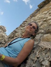
 Here is a picture of Linda next to the Palace Tablet found in House E.
My guess is that she added the map notes in the late 70's and early 80's when she was helping Merle Green Robertson create a new map for the site. Although the Mexican authorities keep records that detail the operation and excavation # of each archaeological dig, this is the only map I have ever found that documents some of them. Those shown here are excavations that took place from 1951 to 1956 in the central precinct. I have digitally mapped this information, but this task is only a small piece of the data puzzle that I am putting together. In case you are curious about the names of the archaeologists on this map, I am going to tell you a little bit about each one of them over the next few entries.
Tablet of the Slaves
The name "Zavala" is shown on the map as having excavated in the Palace area. He worked at Palenque under the well-known Mexican archaeologist, Alberto Ruz. His full name was Lauro Jose Zavala. Linda's map above doesn't display Group IV, where Zavala also excavated and found a well preserved carved monument called "Temple of the Slaves" (above drawing by Linda). His crew was building the modern road into Palenque and accidentally came across a set of residential buildings that we now call Group IV.


