Tuesday, October 28, 2008

Zavala and Group IV


Zavala created a map of Group IV (displayed above) showing where the Tablet of the Slaves was found ("L" on the upper left-hand side of the map) as well as where a grave was uncovered that he called "tumba aislada". This tomb was uncovered while his crew was constructing the modern road leading into the site.

Saturday, October 25, 2008

Transitions

Today I begin the process of transitioning my blog away from one that addresses the conservation of Palenque, Mexico as an archaeological park, to a blog about Palenque GIS and the site's archaeological record. The map displayed above was annotated by Linda Schele upon a blueline print of a base map of the central precinct of Palenque.
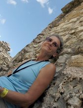
Here is a picture of Linda next to the Palace Tablet found in House E.

My guess is that she added the map notes in the late 70's and early 80's when she was helping Merle Green Robertson create a new map for the site. Although the Mexican authorities keep records that detail the operation and excavation # of each archaeological dig, this is the only map I have ever found that documents some of them. Those shown here are excavations that took place from 1951 to 1956 in the central precinct. I have digitally mapped this information, but this task is only a small piece of the data puzzle that I am putting together. In case you are curious about the names of the archaeologists on this map, I am going to tell you a little bit about each one of them over the next few entries.

Tablet of the Slaves

The name "Zavala" is shown on the map as having excavated in the Palace area. He worked at Palenque under the well-known Mexican archaeologist, Alberto Ruz. His full name was Lauro Jose Zavala. Linda's map above doesn't display Group IV, where Zavala also excavated and found a well preserved carved monument called "Temple of the Slaves" (above drawing by Linda). His crew was building the modern road into Palenque and accidentally came across a set of residential buildings that we now call Group IV.

Tuesday, September 2, 2008

Fuzzy Boundaries

Soon after you arrive at the main entrance gate to Palenque - the one where they take your 20 pesos and ask you what country you are from - you realize that there are other landowners that encroach into the park boundaries. All the painted signs along the road going up into the site are a dead give-away. The boundary for the park was established several years ago, but there are still people who own land within it. I have been told that the government would like to purchase these properties to better protect the site and its archaeology, but they haven't come up with the funds to do this yet.
The first sign you see right at that front gate is the all popular lodging, eating, drinking and music establishment of El Panchan, along with various other businesses. Panchan has some of the best food I have ever eaten and they employ outstanding chefs.

The next establishment along the road doesn't seem to have a name, but has a sign advertising bungalows.


Then there is a youth hostel...

A place called La Palapa...


Next comes Michol Palapa - The word "Michol" is also the name of the nearby river.

Kichanes cabanas and camping

Last, but not least is the Mayabelle. Ed Barnhart and his crew actually mapped part of this property, since the land contains ancient structures.

Tuesday, August 26, 2008

After 5 Thousand Years

I recently received a new National Geographic magazine collector's item publication in the mail.
As I was flipping through the softbound book, I noticed the messages contained on the inside of the front cover.
And then I noticed the inside of the back cover. Delfino Lopez Hidalgo, one of the administrators at the Palenque site from the INAH (the Instituto Nacional de Antropología e Historia) told me that the governor of Chiapas, as well a the National Secretary of Tourism had spent large amounts of money in tourism advertising in order to promote the state of Chiapas. Visit http://www.sectorturismo.gob.mx/wb/sectur/sect_buscador?q=chiapas
to see some of their information. Since visitation is up this year it seems to be working.

Saturday, August 23, 2008

Excusado del Palacio

You may recall a discussion in a previous posting about the possible existence of bathrooms in the Palace. This evening, while looking through many of our old books and enformes about Palenque, I came across the above diagram that was drawn under the direction of Mexican archaeologist, Miguel Angel Fernandez. He excavated at Palenque in the 1940's. The diagram illustrates part of the Palace tower court and clearly shows "la posición" that a man would be able take in order to relieve himself in "el hombre's estación". It even shows the physics of how it might operate. I guess we will have to continue to use our imagination regarding how the women's excusado works. I now have a new-found confidence in our Palenque tour guides because the information that they are giving their audiances comes from a pretty good source!